
Our Vision
“To proactively conserve land in conservation focus areas and pursue projects that secure other significant ecological and community values.”
4,582 acres of land protected

How to Protect Your Land
Donate land to KELT.
Inform KELT of your interest to sell land.
Utilize conservation easements or other legal agreements for landowners interested in retaining ownership while conserving their land in perpetuity.
Support KELT in community campaigns to raise funds to purchase a property of interest.
What We Protect
Key wildlife habitat supporting biological diversity.
Rivers, wetlands, marshes, bays and other waterways.
Working farms.
Forests.
Public access for outdoor recreation.
Aquaculture industry, supporting local economy.
Our regions traditions and history.
Space for outdoor learning and community building.
Healthy air and water.
Landowner Benefits
Donation of land may qualify as a tax-deductible charitable gift.
Granting a conservation easement may result in property tax savings.
Leave a valuable legacy for future generations.
This information doesn't constitute legal or tax advice, and we recommend that landowners consult with a tax advisor, estate planner, and attorney before proceeding with a charitable gift of land or a conservation easement.
Fee Properties
KELT currently stewards 2,592 acres of fee property conservation land. For some landowners, preserving the land they love means they want KELT to own the land - protecting fragile habitat, developing recreation potential, and offering significant public benefit.
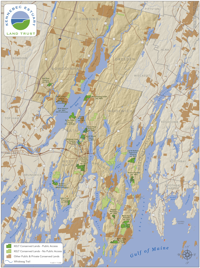
Trail Access
Beaver Pond Preserve, Westport Island - 45 acres
Bonyun Preserve, Westport Island - 118.7 acres
Center Point Preserve, Bowdoinham - 31.76 acres
Green Point Preserve, West Bath - 45 acres
Higgins Mountain Preserve, Georgetown - 41.5 acres
Lilly Pond Community Forest, Bath - 532.78 acres
Merrymeeting Fields Preserve, Woolwich - 125 acres
Morse Pond Preserve, Georgetown - 280.88 acres
Thorne Head Preserve, Bath - 88 acres
Red Rose Preserve, Bowdoinham - 63 acres
Segerstrom Preserve, Westport Island - 159.7 acres
Sewall Woods Preserve, Bath - 109.13 acres
Weber Kelly Preserve, Georgetown - 108.18 acres
Whiskeag Creek Preserve, Bath - 58.5 acres
Water Access
Brick Island Preserve, Bowdoinham - 6 acres
Iceboro Landing, Richmond - 11 acres
Varney Island Preserve, Bath - 9.8 acres
Easement Properties
Conservation Easement
KELT has conserved 1,990 acres through conservation easements. Land is donated or placed under a conservation easement, a legal agreement that remains with the land, forever. They are among the most meaningful legacies a person or family can leave to future generations. When completed, it is the job of the land trust to make sure that promise is kept. Refer to Conservation Property Map for access information.
Easements with public access:
Bath Urban Forest (Whiskeag Trail), Bath - Bath Housing Authority
Butler Head Preserve, Bath - City of Bath
Hamilton Sanctuary, West Bath - Maine Audubon
Schoener Preserve, Georgetown - University of Maine
Agricultural Easement
An agricultural easement is a form of conservation easement. It is designed and developed with farm use as the top priority and remains in effect on the land regardless of ownership. Like a conservation easement, this is a voluntary, legal agreement with the landowner. This keeps the farm in private ownership and as a farm forever. These types of easements support local food in our communities.
Harvest Tide Organics, Bowdoinham - 58.7 acres
Fairwinds Farm, Bowdoinham - 11 acres
Marshfield Farm, Bowdoinham - 58.7 acres